Buoyweather.com do some great interpretation of the NOAA data and other sources, displaying graphs showing peak wave height period and direction, alongside wind speed and direction. There is also a nowcast of surf height.
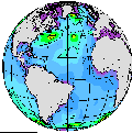
Pick any virtual buoy location from the
map.
Including:
Pembrokeshire
North Devon
Lizard
Plymouth
t+00h | t+06h | t+12h | t+18h | t+24h | t+30h | t+36h | t+42h | t+48h | t+54h | t+60h | t+66h | t+72h | t+78h | t+84h | t+90h | t+96h | t+102h | t+108h | t+114h | t+120h | t+126h | t+132h | t+138h | t+144h | t+150h | t+156h | t+162h | t+168h | t+174h | t+180h | Animation
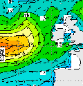
Wave period (Tp) and Direction :
t+00h
| t+06h
| t+12h
| t+18h
| t+24h
| t+30h
| t+36h
| t+42h
| t+48h
| t+54h
| t+60h
| t+66h
| t+72h
| t+78h
| t+84h
| t+90h
| t+96h
| t+102h
| t+108h
| t+114h
| t+120h
| t+126h
| t+132h
| t+138h
| t+144h
| t+150h
| t+156h
| t+162h
| t+168h
| t+174h
| t+180h
| t+180h
Animation
0-126h, 0h,
FNMOC Global WAM Forecasts Wave Height Forecasts by the US Navy Fleet Numerical Modelling Center. The Loop is really handy.
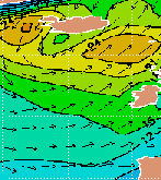
Significant Wave Height (ft.) and Direction
Swell Wave Height (ft.) and Direction
And others.
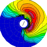
- Spectra for location 62029 (K1) in Sole.
- Spectra for location 62081 (K2) in South Shannon.
- Spectra for location 62105 in Rockall.
- Spectra for location 62106 in Hebridies.
- Spectra for location 62108 300 NM west of Ireland.
- Spectra for location 62163 in North Biscay.
- Spectra for location 63111 in Viking.
- Spectra for location 64045 in Faroes.
![]()